


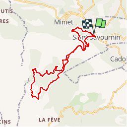
St Savournin - L'aire de la moure -

ARPF
User

Length
21 km

Max alt
711 m

Uphill gradient
807 m
Km-Effort
32 km

Min alt
247 m

Downhill gradient
808 m
Boucle
Yes
Creation date :
2014-12-10 00:00:00.0
Updated on :
2014-12-10 00:00:00.0
6h33
Difficulty : Difficult

FREE GPS app for hiking
 SityTrail
IGN / Geographical institutes
SityTrail Plus
The world is yours!
About
Trail Walking of 21 km to be discovered at Provence-Alpes-Côte d'Azur, Bouches-du-Rhône, Saint-Savournin. This trail is proposed by ARPF.
Description
P2 T1 27/03/14 Philippe
Positioning
Country:
France
Region :
Provence-Alpes-Côte d'Azur
Department/Province :
Bouches-du-Rhône
Municipality :
Saint-Savournin
Location:
Unknown
Start:(Dec)
Start:(UTM)
704471 ; 4809180 (31T) N.
Comments