


St Pons - Col Espigoulier - Col de Bertagne

ARPF
User
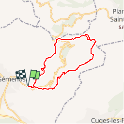

Length
14.3 km

Max alt
884 m

Uphill gradient
806 m
Km-Effort
25 km

Min alt
183 m

Downhill gradient
804 m
Boucle
Yes
Creation date :
2014-12-10 00:00:00.0
Updated on :
2014-12-10 00:00:00.0
5h11
Difficulty : Medium

FREE GPS app for hiking
 SityTrail
IGN / Geographical institutes
SityTrail Plus
The world is yours!
About
Trail Walking of 14.3 km to be discovered at Provence-Alpes-Côte d'Azur, Bouches-du-Rhône, Gémenos. This trail is proposed by ARPF.
Description
P2 T2 Philippe le 03 avril 2014
Positioning
Country:
France
Region :
Provence-Alpes-Côte d'Azur
Department/Province :
Bouches-du-Rhône
Municipality :
Gémenos
Location:
Unknown
Start:(Dec)
Start:(UTM)
714293 ; 4796731 (31T) N.
Comments