


13 Régagnas - Ruines Dalbessy

ARPF
User

Length
9.9 km

Max alt
446 m

Uphill gradient
257 m
Km-Effort
13.3 km

Min alt
337 m

Downhill gradient
255 m
Boucle
Yes
Creation date :
2014-12-10 00:00:00.0
Updated on :
2014-12-10 00:00:00.0
2h50
Difficulty : Easy

FREE GPS app for hiking
 SityTrail
IGN / Geographical institutes
SityTrail Plus
The world is yours!
About
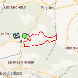
Trail Walking of 9.9 km to be discovered at Provence-Alpes-Côte d'Azur, Bouches-du-Rhône, Belcodène. This trail is proposed by ARPF.
Description
P1 T1 Facile faible dénivellé, sur petit sentier, belles vues, point de vue dégagée, passage a proximité d''habitation sans problème.
Positioning
Country:
France
Region :
Provence-Alpes-Côte d'Azur
Department/Province :
Bouches-du-Rhône
Municipality :
Belcodène
Location:
Unknown
Start:(Dec)
Start:(UTM)
711311 ; 4810545 (31T) N.
Comments