


L'ARBOUSSIE

pelaez
User
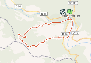

Length
9.2 km

Max alt
239 m

Uphill gradient
240 m
Km-Effort
12.4 km

Min alt
74 m

Downhill gradient
240 m
Boucle
Yes
Creation date :
2021-01-05 16:00:22.795
Updated on :
2021-01-05 16:00:22.795
--
Difficulty : Unknown

FREE GPS app for hiking
 SityTrail
IGN / Geographical institutes
SityTrail Plus
The world is yours!
About
Trail Walking of 9.2 km to be discovered at Occitania, Hérault, Roquebrun. This trail is proposed by pelaez.


Positioning
Country:
France
Region :
Occitania
Department/Province :
Hérault
Municipality :
Roquebrun
Location:
Unknown
Start:(Dec)
Start:(UTM)
502152 ; 4816316 (31T) N.
Comments