


Tanargue Jour 1

Cricounet84
User
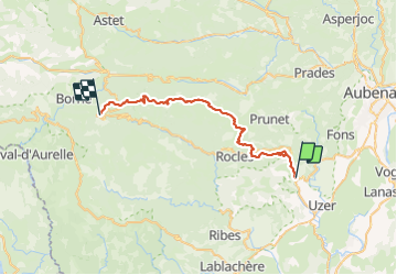

Length
39 km

Max alt
1440 m

Uphill gradient
1852 m
Km-Effort
61 km

Min alt
216 m

Downhill gradient
869 m
Boucle
No
Creation date :
2014-12-10 00:00:00.0
Updated on :
2014-12-10 00:00:00.0
12h00
Difficulty : Difficult

FREE GPS app for hiking
 SityTrail
IGN / Geographical institutes
SityTrail Plus
The world is yours!
About
Trail Walking of 39 km to be discovered at Auvergne-Rhône-Alpes, Ardèche, Largentière. This trail is proposed by Cricounet84.
Photos


42 photos in total. Please click on a photo to see them all in the gallery.


Positioning
Country:
France
Region :
Auvergne-Rhône-Alpes
Department/Province :
Ardèche
Municipality :
Largentière
Location:
Unknown
Start:(Dec)
Start:(UTM)
602754 ; 4933103 (31T) N.
Comments