


12409472-Carry le Rouet 06.81

togolo28
User
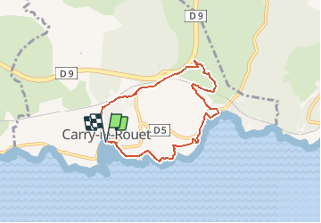

Length
6.8 km

Max alt
77 m

Uphill gradient
139 m
Km-Effort
8.7 km

Min alt
1 m

Downhill gradient
145 m
Boucle
Yes
Creation date :
2021-01-06 15:51:56.671
Updated on :
2021-01-06 15:52:29.989
--
Difficulty : Very easy

FREE GPS app for hiking
 SityTrail
IGN / Geographical institutes
SityTrail Plus
The world is yours!
About
Trail Walking of 6.8 km to be discovered at Provence-Alpes-Côte d'Azur, Bouches-du-Rhône, Carry-le-Rouet. This trail is proposed by togolo28.
Positioning
Country:
France
Region :
Provence-Alpes-Côte d'Azur
Department/Province :
Bouches-du-Rhône
Municipality :
Carry-le-Rouet
Location:
Unknown
Start:(Dec)
Start:(UTM)
674496 ; 4799781 (31T) N.
Comments