


oliveraie

Bwattier
User
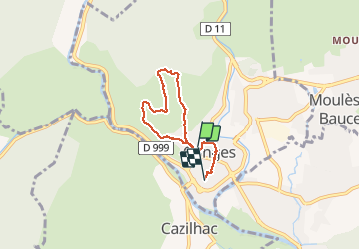

Length
4.7 km

Max alt
348 m

Uphill gradient
251 m
Km-Effort
8.1 km

Min alt
155 m

Downhill gradient
257 m
Boucle
No
Creation date :
2021-01-06 13:22:50.776
Updated on :
2021-01-06 16:03:17.697
2h22
Difficulty : Very easy

FREE GPS app for hiking
 SityTrail
IGN / Geographical institutes
SityTrail Plus
The world is yours!
About
Trail Walking of 4.7 km to be discovered at Occitania, Hérault, Ganges. This trail is proposed by Bwattier.
Positioning
Country:
France
Region :
Occitania
Department/Province :
Hérault
Municipality :
Ganges
Location:
Unknown
Start:(Dec)
Start:(UTM)
556578 ; 4864882 (31T) N.
Comments