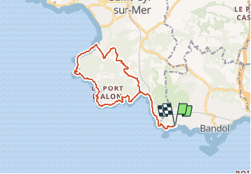
Boucle Bandol - Port d'Alon - Dune de sable - La Madrague - Port d'Alon - Bandol

affinetataille
User GUIDE

Length
16.6 km

Max alt
163 m

Uphill gradient
517 m
Km-Effort
23 km

Min alt
1 m

Downhill gradient
517 m
Boucle
Yes
Creation date :
2021-01-07 07:09:38.333
Updated on :
2021-01-07 22:25:55.099
7h00
Difficulty : Medium

FREE GPS app for hiking
 SityTrail
IGN / Geographical institutes
SityTrail Plus
The world is yours!
About
Trail Walking of 16.6 km to be discovered at Provence-Alpes-Côte d'Azur, Var, Bandol. This trail is proposed by affinetataille.
Photos


26 photos in total. Please click on a photo to see them all in the gallery.
Positioning
Country:
France
Region :
Provence-Alpes-Côte d'Azur
Department/Province :
Var
Municipality :
Bandol
Location:
Unknown
Start:(Dec)
Start:(UTM)
722278 ; 4779634 (31T) N.
Comments