
Metzing Loupershouse

piem
User
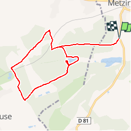

Length
8.7 km

Max alt
280 m

Uphill gradient
154 m
Km-Effort
10.7 km

Min alt
233 m

Downhill gradient
155 m
Boucle
Yes
Creation date :
2014-12-10 00:00:00.0
Updated on :
2014-12-10 00:00:00.0
2h18
Difficulty : Easy

FREE GPS app for hiking
 SityTrail
IGN / Geographical institutes
SityTrail Plus
The world is yours!
About
Trail Walking of 8.7 km to be discovered at Grand Est, Moselle, Metzing. This trail is proposed by piem.
Description
Circuit facile et agréable sans aucune difficulté sur chemin carrossable. Un petit parking permet de stationner son véhicule au départ de l'itinéraire.
Photos


Positioning
Country:
France
Region :
Grand Est
Department/Province :
Moselle
Municipality :
Metzing
Location:
Unknown
Start:(Dec)
Start:(UTM)
350906 ; 5440354 (32U) N.
Comments