


TRIEVE - LAFFREY - LE GRAND SERRE

JMHRX2
User
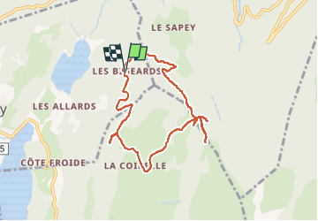

Length
8.3 km

Max alt
1486 m

Uphill gradient
561 m
Km-Effort
15.7 km

Min alt
1048 m

Downhill gradient
554 m
Boucle
Yes
Creation date :
2021-01-09 09:20:01.405
Updated on :
2022-10-12 07:11:45.699
3h28
Difficulty : Very easy

FREE GPS app for hiking
 SityTrail
IGN / Geographical institutes
SityTrail Plus
The world is yours!
About
Trail Walking of 8.3 km to be discovered at Auvergne-Rhône-Alpes, Isère, Laffrey. This trail is proposed by JMHRX2.
Positioning
Country:
France
Region :
Auvergne-Rhône-Alpes
Department/Province :
Isère
Municipality :
Laffrey
Location:
Unknown
Start:(Dec)
Start:(UTM)
720597 ; 4990180 (31T) N.
Comments