


2014-04-05 Moissy Cramayel

Lucquiaud
User
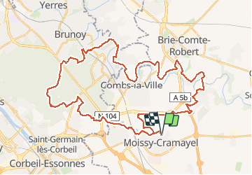

Length
49 km

Max alt
107 m

Uphill gradient
527 m
Km-Effort
56 km

Min alt
43 m

Downhill gradient
526 m
Boucle
Yes
Creation date :
2018-09-15 15:06:47.003
Updated on :
2018-09-15 15:06:47.462
3h25
Difficulty : Easy

FREE GPS app for hiking
 SityTrail
IGN / Geographical institutes
SityTrail Plus
The world is yours!
About
Trail Mountain bike of 49 km to be discovered at Ile-de-France, Seine-et-Marne, Moissy-Cramayel. This trail is proposed by Lucquiaud.
Positioning
Country:
France
Region :
Ile-de-France
Department/Province :
Seine-et-Marne
Municipality :
Moissy-Cramayel
Location:
Unknown
Start:(Dec)
Start:(UTM)
470157 ; 5386635 (31U) N.
Comments