


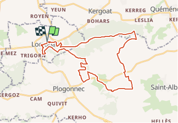
Locronan - Penhoat

cron
User

Length
19.7 km

Max alt
281 m

Uphill gradient
394 m
Km-Effort
25 km

Min alt
109 m

Downhill gradient
398 m
Boucle
Yes
Creation date :
2021-01-10 16:31:49.645
Updated on :
2022-02-10 17:09:20.636
4h30
Difficulty : Medium

FREE GPS app for hiking
 SityTrail
IGN / Geographical institutes
SityTrail Plus
The world is yours!
About
Trail On foot of 19.7 km to be discovered at Brittany, Finistère, Locronan. This trail is proposed by cron.
Description
Parking derrière l'église de Locronan.
Positioning
Country:
France
Region :
Brittany
Department/Province :
Finistère
Municipality :
Locronan
Location:
Unknown
Start:(Dec)
Start:(UTM)
410176 ; 5328053 (30U) N.
Comments