Trail Walking Capdenac-Gare - Chapelle saint loup - Photo

Chapelle saint loup

 xamax12
xamax12

User

© OpenStreetMap contributors
Length
Length
12.7 km
Max alt
Max alt
426 m
Uphill gradient
Uphill gradient
369 m
Km-Effort
Km-Effort  
17.6 km
Min alt
Min alt
173 m
Downhill gradient
Downhill gradient
368 m
Boucle
Boucle
Yes
Creation date :
2014-12-10 00:00:00.0
Updated on :
2014-12-10 00:00:00.0

(0 Reviews)

Walking
Walking
3h20
Difficulty : Medium

Scan this QR Code to open this trail in the SityTrail application

FREE GPS app for hiking

Logo SityTrail SityTrail

IGN / Geographical institutes

Download SityTrail from the App Store Download SityTrail from Google Play

Logo SityTrail SityTrail Plus

The world is yours!

Download SityTrail from the App Store Download SityTrail from Google Play Download SityTrail on Huawei AppGallery

About

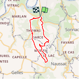
Trail Walking of 12.7 km to be discovered at Occitania, Aveyron, Capdenac-Gare. This trail is proposed by xamax12.

Description

Petite randonnée a travers la forêt et quelques champs avec de belles vues sur les vallées environnantes, le plus dur étant la première montée pour rejoindre le plateau après c'est juste vallonné, mais la dernière descente est à prendre avec prudence a cause de la pente est des cailloux. avec vers la mie parcourt une jolie petite chapelle dite de saint loup.

Elevation profile

Positioning

Country:
France
Region :
Occitania
Department/Province :
Aveyron
Municipality :
Capdenac-Gare
Location:
Unknown
Start:(UTM)
426451 ; 4934264 (31T) N.


Close
My subscriptions