


bois de dampierre

nicolasdresse
User
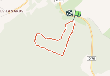

Length
3.4 km

Max alt
352 m

Uphill gradient
69 m
Km-Effort
4.3 km

Min alt
291 m

Downhill gradient
72 m
Boucle
Yes
Creation date :
2018-09-29 20:52:36.744
Updated on :
2023-06-18 13:47:39.991
59m
Difficulty : Easy

FREE GPS app for hiking
 SityTrail
IGN / Geographical institutes
SityTrail Plus
The world is yours!
About
Trail Walking of 3.4 km to be discovered at Bourgogne-Franche-Comté, Haute-Saône, Dampierre-sur-Linotte. This trail is proposed by nicolasdresse.
Description
courte. rando
Positioning
Country:
France
Region :
Bourgogne-Franche-Comté
Department/Province :
Haute-Saône
Municipality :
Dampierre-sur-Linotte
Location:
Unknown
Start:(Dec)
Start:(UTM)
292223 ; 5269802 (32T) N.
Comments