


Isolabona Perinaldo

jlrayon
User
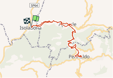

Length
15.4 km

Max alt
520 m

Uphill gradient
921 m
Km-Effort
28 km

Min alt
120 m

Downhill gradient
921 m
Boucle
Yes
Creation date :
2014-12-10 00:00:00.0
Updated on :
2014-12-10 00:00:00.0
6h36
Difficulty : Medium

FREE GPS app for hiking
 SityTrail
IGN / Geographical institutes
SityTrail Plus
The world is yours!
About
Trail Walking of 15.4 km to be discovered at Liguria, Imperia, Isolabona. This trail is proposed by jlrayon.
Description
Isolabona Perinaldo
Photos


Positioning
Country:
Italy
Region :
Liguria
Department/Province :
Imperia
Municipality :
Isolabona
Location:
Unknown
Start:(Dec)
Start:(UTM)
390775 ; 4859427 (32T) N.
Comments