


Bois de Fonfroide

Ada11
User GUIDE
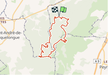

Length
17.9 km

Max alt
257 m

Uphill gradient
348 m
Km-Effort
23 km

Min alt
108 m

Downhill gradient
348 m
Boucle
Yes
Creation date :
2021-01-13 08:42:08.698
Updated on :
2021-01-16 09:05:27.166
4h03
Difficulty : Easy

FREE GPS app for hiking
 SityTrail
IGN / Geographical institutes
SityTrail Plus
The world is yours!
About
Trail Walking of 17.9 km to be discovered at Occitania, Aude, Narbonne. This trail is proposed by Ada11.
Description
Beaucoup de pistes, de vent, peu de vues, cimetière de voitures.
Positioning
Country:
France
Region :
Occitania
Department/Province :
Aude
Municipality :
Narbonne
Location:
Unknown
Start:(Dec)
Start:(UTM)
491515 ; 4775290 (31T) N.
Comments