


Circuit d' Adé 1

mitch1952
User
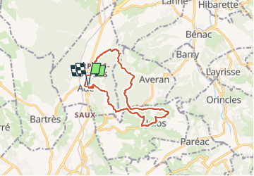

Length
12.6 km

Max alt
642 m

Uphill gradient
379 m
Km-Effort
17.6 km

Min alt
404 m

Downhill gradient
379 m
Boucle
Yes
Creation date :
2021-01-17 10:59:43.849
Updated on :
2022-06-07 13:11:54.313
4h00
Difficulty : Difficult

FREE GPS app for hiking
 SityTrail
IGN / Geographical institutes
SityTrail Plus
The world is yours!
About
Trail Walking of 12.6 km to be discovered at Occitania, Hautespyrenees, Adé. This trail is proposed by mitch1952.
Positioning
Country:
France
Region :
Occitania
Department/Province :
Hautespyrenees
Municipality :
Adé
Location:
Unknown
Start:(Dec)
Start:(UTM)
741783 ; 4780119 (30T) N.
Comments