


Barrages Zola-Bimont

Berpav
User

Length
8 km

Max alt
374 m

Uphill gradient
226 m
Km-Effort
11 km

Min alt
228 m

Downhill gradient
224 m
Boucle
Yes
Creation date :
2021-01-17 11:56:12.935
Updated on :
2021-01-18 10:36:00.515
2h30
Difficulty : Medium

FREE GPS app for hiking
 SityTrail
IGN / Geographical institutes
SityTrail Plus
The world is yours!
About
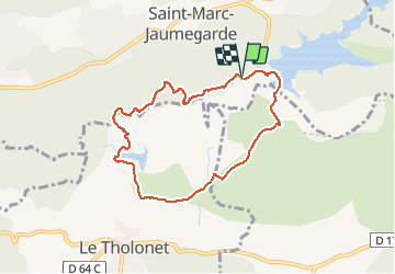
Trail Walking of 8 km to be discovered at Provence-Alpes-Côte d'Azur, Bouches-du-Rhône, Saint-Marc-Jaumegarde. This trail is proposed by Berpav.
Photos


Positioning
Country:
France
Region :
Provence-Alpes-Côte d'Azur
Department/Province :
Bouches-du-Rhône
Municipality :
Saint-Marc-Jaumegarde
Location:
Unknown
Start:(Dec)
Start:(UTM)
704442 ; 4823999 (31T) N.
Comments
Très beaux paysages.