


monfroid

jphugon
User
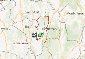

Length
9.1 km

Max alt
465 m

Uphill gradient
242 m
Km-Effort
12.3 km

Min alt
266 m

Downhill gradient
243 m
Boucle
Yes
Creation date :
2021-01-17 11:59:12.179
Updated on :
2021-01-17 18:01:46.061
2h52
Difficulty : Very easy

FREE GPS app for hiking
 SityTrail
IGN / Geographical institutes
SityTrail Plus
The world is yours!
About
Trail Walking of 9.1 km to be discovered at Auvergne-Rhône-Alpes, Drôme, Ratières. This trail is proposed by jphugon.
Positioning
Country:
France
Region :
Auvergne-Rhône-Alpes
Department/Province :
Drôme
Municipality :
Ratières
Location:
Unknown
Start:(Dec)
Start:(UTM)
655405 ; 5003472 (31T) N.
Comments