


variante ch des bigues

flux99
User
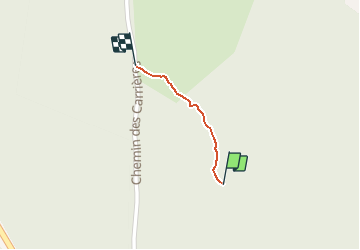

Length
280 m

Max alt
289 m

Uphill gradient
0 m
Km-Effort
286 m

Min alt
286 m

Downhill gradient
2 m
Boucle
No
Creation date :
2021-01-19 13:34:42.186
Updated on :
2021-01-19 13:41:25.963
6m
Difficulty : Very easy

FREE GPS app for hiking
 SityTrail
IGN / Geographical institutes
SityTrail Plus
The world is yours!
About
Trail Walking of 280 m to be discovered at Auvergne-Rhône-Alpes, Isère, Parmilieu. This trail is proposed by flux99.
Positioning
Country:
France
Region :
Auvergne-Rhône-Alpes
Department/Province :
Isère
Municipality :
Parmilieu
Location:
Unknown
Start:(Dec)
Start:(UTM)
682417 ; 5077195 (31T) N.
Comments