


Vercors Engins plateau de Sornin

c.gourme
User
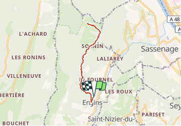

Length
12.5 km

Max alt
1538 m

Uphill gradient
681 m
Km-Effort
22 km

Min alt
911 m

Downhill gradient
681 m
Boucle
Yes
Creation date :
2021-01-19 09:08:16.0
Updated on :
2021-01-21 09:07:45.68
5h33
Difficulty : Medium

FREE GPS app for hiking
 SityTrail
IGN / Geographical institutes
SityTrail Plus
The world is yours!
About
Trail Snowshoes of 12.5 km to be discovered at Auvergne-Rhône-Alpes, Isère, Engins. This trail is proposed by c.gourme.
Positioning
Country:
France
Region :
Auvergne-Rhône-Alpes
Department/Province :
Isère
Municipality :
Engins
Location:
Unknown
Start:(Dec)
Start:(UTM)
705687 ; 5006634 (31T) N.
Comments