


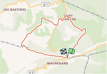
Rochefort la Bedoule - Font Blanche

soca
User

Length
9.4 km

Max alt
560 m

Uphill gradient
348 m
Km-Effort
14.1 km

Min alt
276 m

Downhill gradient
350 m
Boucle
Yes
Creation date :
2021-01-19 15:45:49.963
Updated on :
2021-01-19 15:49:50.419
3h30
Difficulty : Medium

FREE GPS app for hiking
 SityTrail
IGN / Geographical institutes
SityTrail Plus
The world is yours!
About
Trail Walking of 9.4 km to be discovered at Provence-Alpes-Côte d'Azur, Bouches-du-Rhône, Roquefort-la-Bédoule. This trail is proposed by soca.
Description
Le grand Caunet - Font Blanche - GR 98 - Le Montonnier - retour
Positioning
Country:
France
Region :
Provence-Alpes-Côte d'Azur
Department/Province :
Bouches-du-Rhône
Municipality :
Roquefort-la-Bédoule
Location:
Unknown
Start:(Dec)
Start:(UTM)
716857 ; 4790362 (31T) N.
Comments