


font de l'orme

Mascart
User

Length
13 km

Max alt
244 m

Uphill gradient
203 m
Km-Effort
15.7 km

Min alt
118 m

Downhill gradient
203 m
Boucle
Yes
Creation date :
2021-01-19 13:19:51.947
Updated on :
2021-01-19 16:20:04.235
2h48
Difficulty : Medium

FREE GPS app for hiking
 SityTrail
IGN / Geographical institutes
SityTrail Plus
The world is yours!
About
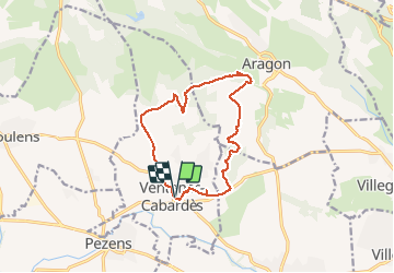
Trail Mountain bike of 13 km to be discovered at Occitania, Aude, Ventenac-Cabardès. This trail is proposed by Mascart.
Description
la bouriette
Positioning
Country:
France
Region :
Occitania
Department/Province :
Aude
Municipality :
Ventenac-Cabardès
Location:
Unknown
Start:(Dec)
Start:(UTM)
441993 ; 4790526 (31T) N.
Comments