


peigross

vincente204
User
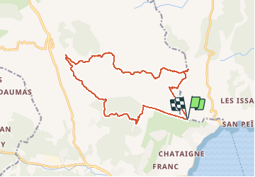

Length
17.7 km

Max alt
362 m

Uphill gradient
627 m
Km-Effort
26 km

Min alt
15 m

Downhill gradient
633 m
Boucle
Yes
Creation date :
2021-01-19 08:03:15.275
Updated on :
2021-01-19 16:45:07.388
5h59
Difficulty : Easy

FREE GPS app for hiking
 SityTrail
IGN / Geographical institutes
SityTrail Plus
The world is yours!
About
Trail Walking of 17.7 km to be discovered at Provence-Alpes-Côte d'Azur, Var, Roquebrune-sur-Argens. This trail is proposed by vincente204.
Description
difficile
Positioning
Country:
France
Region :
Provence-Alpes-Côte d'Azur
Department/Province :
Var
Municipality :
Roquebrune-sur-Argens
Location:
Unknown
Start:(Dec)
Start:(UTM)
310637 ; 4801645 (32T) N.
Comments