


caussols le 24 JANVIER

clintest
User
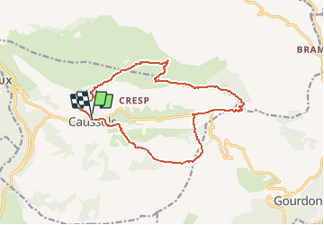

Length
16.7 km

Max alt
1322 m

Uphill gradient
414 m
Km-Effort
22 km

Min alt
1081 m

Downhill gradient
419 m
Boucle
Yes
Creation date :
2021-01-20 19:22:46.649
Updated on :
2021-01-20 19:23:22.999
--
Difficulty : Very easy

FREE GPS app for hiking
 SityTrail
IGN / Geographical institutes
SityTrail Plus
The world is yours!
About
Trail On foot of 16.7 km to be discovered at Provence-Alpes-Côte d'Azur, Maritime Alps, Caussols. This trail is proposed by clintest.
Positioning
Country:
France
Region :
Provence-Alpes-Côte d'Azur
Department/Province :
Maritime Alps
Municipality :
Caussols
Location:
Unknown
Start:(Dec)
Start:(UTM)
330895 ; 4845343 (32T) N.
Comments