


le télégraphe

michelpaulin
User
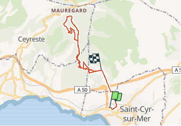

Length
15.1 km

Max alt
464 m

Uphill gradient
497 m
Km-Effort
21 km

Min alt
15 m

Downhill gradient
374 m
Boucle
No
Creation date :
2021-01-19 08:24:36.803
Updated on :
2021-01-21 08:10:39.384
4h26
Difficulty : Easy

FREE GPS app for hiking
 SityTrail
IGN / Geographical institutes
SityTrail Plus
The world is yours!
About
Trail Walking of 15.1 km to be discovered at Provence-Alpes-Côte d'Azur, Var, Saint-Cyr-sur-Mer. This trail is proposed by michelpaulin.
Description
belle randonnée facile
Positioning
Country:
France
Region :
Provence-Alpes-Côte d'Azur
Department/Province :
Var
Municipality :
Saint-Cyr-sur-Mer
Location:
Unknown
Start:(Dec)
Start:(UTM)
718828 ; 4784799 (31T) N.
Comments