Trail Walking Cassis - RB-envau-gardiole - Photo
© OpenStreetMap contributors
Length
Length
15 km
Max alt
Max alt
218 m
Uphill gradient
Uphill gradient
543 m
Km-Effort
Km-Effort  
22 km
Min alt
Min alt
2 m
Downhill gradient
Downhill gradient
543 m
Boucle
Boucle
Yes
Creation date :
2014-12-10 00:00:00.0
Updated on :
2014-12-10 00:00:00.0

(1 Reviews)

Walking
Walking
4h51
Difficulty : Medium

Scan this QR Code to open this trail in the SityTrail application

FREE GPS app for hiking

Logo SityTrail SityTrail

IGN / Geographical institutes

Download SityTrail from the App Store Download SityTrail from Google Play

Logo SityTrail SityTrail Plus

The world is yours!

Download SityTrail from the App Store Download SityTrail from Google Play Download SityTrail on Huawei AppGallery

About

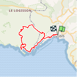
Trail Walking of 15 km to be discovered at Provence-Alpes-Côte d'Azur, Bouches-du-Rhône, Cassis. This trail is proposed by raymondfn.

Description

Cassis (port), calanque de Port-Miou, le Trou Souffleur, calanque de Port Pin, calanque d'En Vau (belvédère puis accès mer), le vallon d'En Vau, Maison forrestière la Gardiole, plateau des Mussuguières, Pas des Marmots, plage du Bestouan, Cassis (port).

Elevation profile

Positioning

Country:
France
Region :
Provence-Alpes-Côte d'Azur
Department/Province :
Bouches-du-Rhône
Municipality :
Cassis
Location:
Unknown
Start:(UTM)
706185 ; 4787706 (31T) N.

Comments

Please log in to post a review or rate the element


Magnifique !


Close
My subscriptions