Trail Walking Marseille - RB-sugiton-candelle-puget - Photo
© OpenStreetMap contributors
Length
Length
15.8 km
Max alt
Max alt
554 m
Uphill gradient
Uphill gradient
825 m
Km-Effort
Km-Effort  
27 km
Min alt
Min alt
5 m
Downhill gradient
Downhill gradient
825 m
Boucle
Boucle
Yes
Creation date :
2014-12-10 00:00:00.0
Updated on :
2014-12-10 00:00:00.0

(1 Reviews)

Walking
Walking
5h47
Difficulty : Medium

Scan this QR Code to open this trail in the SityTrail application

FREE GPS app for hiking

Logo SityTrail SityTrail

IGN / Geographical institutes

Download SityTrail from the App Store Download SityTrail from Google Play

Logo SityTrail SityTrail Plus

The world is yours!

Download SityTrail from the App Store Download SityTrail from Google Play Download SityTrail on Huawei AppGallery

About

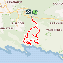
Trail Walking of 15.8 km to be discovered at Provence-Alpes-Côte d'Azur, Bouches-du-Rhône, Marseille. This trail is proposed by raymondfn.

Description

Col de la Gineste, col Ricard, falaises de Luminy, col de Sugiton, la vigie de Sugiton (belle vue sur les calanques de Morgiou et de Sugiton avec table d'orientation), calanque de Sugiton, falaise des Toits, col de la Candelle (sous la Grande Candelle, très belle vue), Mont Puget (variante A-R), col Ricars, le Pain de Sucre, col de la Gineste

Elevation profile

Positioning

Country:
France
Region :
Provence-Alpes-Côte d'Azur
Department/Province :
Bouches-du-Rhône
Municipality :
Marseille
Location:
9th Arrondissement
Start:(UTM)
699467 ; 4790392 (31T) N.

Comments

Please log in to post a review or rate the element


Close
My subscriptions