


COGNY (10 km - D. 305 m)

Thomasdanielle
User
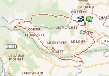

Length
10.4 km

Max alt
524 m

Uphill gradient
305 m
Km-Effort
14.4 km

Min alt
291 m

Downhill gradient
305 m
Boucle
Yes
Creation date :
2021-01-24 10:37:29.146
Updated on :
2021-01-24 11:15:48.174
--
Difficulty : Easy

FREE GPS app for hiking
 SityTrail
IGN / Geographical institutes
SityTrail Plus
The world is yours!
About
Trail On foot of 10.4 km to be discovered at Auvergne-Rhône-Alpes, Rhône, Cogny. This trail is proposed by Thomasdanielle.
Description
D/A Salle des fêtes de Cogny
Positioning
Country:
France
Region :
Auvergne-Rhône-Alpes
Department/Province :
Rhône
Municipality :
Cogny
Location:
Unknown
Start:(Dec)
Start:(UTM)
625792 ; 5094246 (31T) N.
Comments