


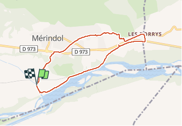
84 Merindol bord de Durance

chris13370
User

Length
8 km

Max alt
172 m

Uphill gradient
80 m
Km-Effort
9.1 km

Min alt
115 m

Downhill gradient
83 m
Boucle
Yes
Creation date :
2021-01-24 12:46:13.216
Updated on :
2021-01-24 14:42:32.14
1h45
Difficulty : Very easy

FREE GPS app for hiking
 SityTrail
IGN / Geographical institutes
SityTrail Plus
The world is yours!
About
Trail Walking of 8 km to be discovered at Provence-Alpes-Côte d'Azur, Vaucluse, Mérindol. This trail is proposed by chris13370.
Description
retour par les Borrys et petites routes peu fréquentées.
Positioning
Country:
France
Region :
Provence-Alpes-Côte d'Azur
Department/Province :
Vaucluse
Municipality :
Mérindol
Location:
Unknown
Start:(Dec)
Start:(UTM)
677051 ; 4845790 (31T) N.
Comments