


Les têtes

orsel
User GUIDE

Length
10 km

Max alt
2027 m

Uphill gradient
467 m
Km-Effort
16.3 km

Min alt
1542 m

Downhill gradient
484 m
Boucle
Yes
Creation date :
2021-01-24 09:15:19.586
Updated on :
2021-01-24 17:20:07.878
4h02
Difficulty : Medium

FREE GPS app for hiking
 SityTrail
IGN / Geographical institutes
SityTrail Plus
The world is yours!
About
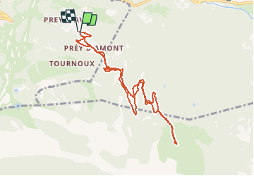
Trail Cross-country skiing of 10 km to be discovered at Provence-Alpes-Côte d'Azur, Hautes-Alpes, Puy-Saint-Vincent. This trail is proposed by orsel.
Positioning
Country:
France
Region :
Provence-Alpes-Côte d'Azur
Department/Province :
Hautes-Alpes
Municipality :
Puy-Saint-Vincent
Location:
Unknown
Start:(Dec)
Start:(UTM)
302779 ; 4965588 (32T) N.
Comments