


35km BSC Bélignieu

Valery01
User
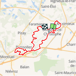

Length
34 km

Max alt
290 m

Uphill gradient
527 m
Km-Effort
41 km

Min alt
201 m

Downhill gradient
529 m
Boucle
Yes
Creation date :
2014-12-10 00:00:00.0
Updated on :
2014-12-10 00:00:00.0
2h19
Difficulty : Unknown

FREE GPS app for hiking
 SityTrail
IGN / Geographical institutes
SityTrail Plus
The world is yours!
About
Trail Mountain bike of 34 km to be discovered at Auvergne-Rhône-Alpes, Ain, Bourg-Saint-Christophe. This trail is proposed by Valery01.
Positioning
Country:
France
Region :
Auvergne-Rhône-Alpes
Department/Province :
Ain
Municipality :
Bourg-Saint-Christophe
Location:
Unknown
Start:(Dec)
Start:(UTM)
667117 ; 5083843 (31T) N.
Comments