


bey

mcterret
User
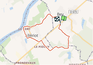

Length
7.7 km

Max alt
211 m

Uphill gradient
63 m
Km-Effort
8.5 km

Min alt
170 m

Downhill gradient
63 m
Boucle
Yes
Creation date :
2021-01-24 13:11:21.619
Updated on :
2021-01-26 07:55:41.379
1h51
Difficulty : Very easy

FREE GPS app for hiking
 SityTrail
IGN / Geographical institutes
SityTrail Plus
The world is yours!
About
Trail Walking of 7.7 km to be discovered at Bourgogne-Franche-Comté, Saône-et-Loire, Bey. This trail is proposed by mcterret.
Positioning
Country:
France
Region :
Bourgogne-Franche-Comté
Department/Province :
Saône-et-Loire
Municipality :
Bey
Location:
Unknown
Start:(Dec)
Start:(UTM)
649711 ; 5186626 (31T) N.
Comments