


Les Taillades - Sommet du Catelas - Vallon du Colombier

ARPF
User
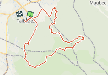

Length
15.3 km

Max alt
504 m

Uphill gradient
548 m
Km-Effort
23 km

Min alt
112 m

Downhill gradient
553 m
Boucle
Yes
Creation date :
2014-12-10 00:00:00.0
Updated on :
2014-12-10 00:00:00.0
6h48
Difficulty : Difficult

FREE GPS app for hiking
 SityTrail
IGN / Geographical institutes
SityTrail Plus
The world is yours!
About
Trail Walking of 15.3 km to be discovered at Provence-Alpes-Côte d'Azur, Vaucluse, Taillades. This trail is proposed by ARPF.
Description
P3 T3 09/04/2014 Avec Jeanne.
Positioning
Country:
France
Region :
Provence-Alpes-Côte d'Azur
Department/Province :
Vaucluse
Municipality :
Taillades
Location:
Unknown
Start:(Dec)
Start:(UTM)
668299 ; 4855547 (31T) N.
Comments