


grandvalira

lablaquiere
User
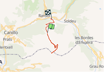

Length
9.2 km

Max alt
2559 m

Uphill gradient
486 m
Km-Effort
17 km

Min alt
1670 m

Downhill gradient
884 m
Boucle
No
Creation date :
2021-01-29 09:23:01.005
Updated on :
2021-01-29 12:49:57.395
3h26
Difficulty : Very easy

FREE GPS app for hiking
 SityTrail
IGN / Geographical institutes
SityTrail Plus
The world is yours!
About
Trail Touring skiing of 9.2 km to be discovered at Andorra. This trail is proposed by lablaquiere.
Positioning
Country:
Andorra
Region :
Unknown
Department/Province :
Unknown
Municipality :
Unknown
Location:
Unknown
Start:(Dec)
Start:(UTM)
388484 ; 4713519 (31T) N.
Comments