


Sablet. Seguret

kephas
User
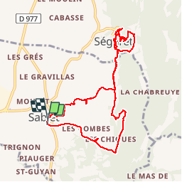

Length
10.9 km

Max alt
350 m

Uphill gradient
344 m
Km-Effort
15.5 km

Min alt
157 m

Downhill gradient
343 m
Boucle
Yes
Creation date :
2014-12-10 00:00:00.0
Updated on :
2014-12-10 00:00:00.0
3h20
Difficulty : Easy

FREE GPS app for hiking
 SityTrail
IGN / Geographical institutes
SityTrail Plus
The world is yours!
About
Trail Walking of 10.9 km to be discovered at Provence-Alpes-Côte d'Azur, Vaucluse, Sablet. This trail is proposed by kephas.
Positioning
Country:
France
Region :
Provence-Alpes-Côte d'Azur
Department/Province :
Vaucluse
Municipality :
Sablet
Location:
Unknown
Start:(Dec)
Start:(UTM)
660392 ; 4895056 (31T) N.
Comments