


plan

lygi
User
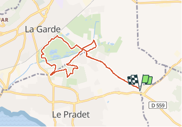

Length
10 km

Max alt
34 m

Uphill gradient
57 m
Km-Effort
10.7 km

Min alt
19 m

Downhill gradient
57 m
Boucle
Yes
Creation date :
2021-01-30 08:15:12.973
Updated on :
2021-01-30 10:34:55.884
2h18
Difficulty : Very easy

FREE GPS app for hiking
 SityTrail
IGN / Geographical institutes
SityTrail Plus
The world is yours!
About
Trail Nordic walking of 10 km to be discovered at Provence-Alpes-Côte d'Azur, Var, Le Pradet. This trail is proposed by lygi.
Positioning
Country:
France
Region :
Provence-Alpes-Côte d'Azur
Department/Province :
Var
Municipality :
Le Pradet
Location:
Unknown
Start:(Dec)
Start:(UTM)
259651 ; 4777213 (32T) N.
Comments