


le pain de munition

amiral13
User GUIDE

Length
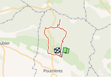
11.1 km

Max alt
608 m

Uphill gradient
322 m
Km-Effort
15.4 km

Min alt
315 m

Downhill gradient
322 m
Boucle
Yes
Creation date :
2021-01-31 10:05:33.625
Updated on :
2021-01-31 16:29:33.574
3h41
Difficulty : Easy

FREE GPS app for hiking
 SityTrail
IGN / Geographical institutes
SityTrail Plus
The world is yours!
About
Trail Walking of 11.1 km to be discovered at Provence-Alpes-Côte d'Azur, Var, Pourrières. This trail is proposed by amiral13.
Photos


Positioning
Country:
France
Region :
Provence-Alpes-Côte d'Azur
Department/Province :
Var
Municipality :
Pourrières
Location:
Unknown
Start:(Dec)
Start:(UTM)
721806 ; 4821617 (31T) N.
Comments