


Rossignol

Airelle
User
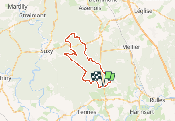

Length
22 km

Max alt
456 m

Uphill gradient
420 m
Km-Effort
28 km

Min alt
365 m

Downhill gradient
420 m
Boucle
Yes
Creation date :
2021-01-31 09:06:08.0
Updated on :
2021-02-04 16:21:31.493
5h11
Difficulty : Difficult

FREE GPS app for hiking
 SityTrail
IGN / Geographical institutes
SityTrail Plus
The world is yours!
About
Trail Walking of 22 km to be discovered at Wallonia, Luxembourg, Tintigny. This trail is proposed by Airelle.
Positioning
Country:
Belgium
Region :
Wallonia
Department/Province :
Luxembourg
Municipality :
Tintigny
Location:
Rossignol
Start:(Dec)
Start:(UTM)
678839 ; 5511587 (31U) N.
Comments