Vassieux butte de St Genix

sedrix
User
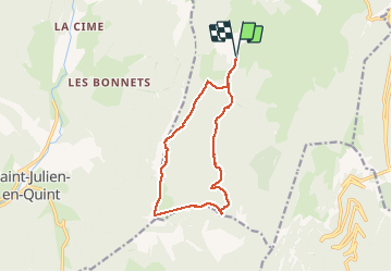

Length
12.9 km

Max alt
1619 m

Uphill gradient
524 m
Km-Effort
19.9 km

Min alt
1170 m

Downhill gradient
525 m
Boucle
Yes
Creation date :
2021-01-31 09:31:40.695
Updated on :
2021-02-01 12:34:47.048
3h15
Difficulty : Medium

FREE GPS app for hiking
 SityTrail
IGN / Geographical institutes
SityTrail Plus
The world is yours!
About
Trail Walking of 12.9 km to be discovered at Auvergne-Rhône-Alpes, Drôme, Vassieux-en-Vercors. This trail is proposed by sedrix.
Positioning
Country:
France
Region :
Auvergne-Rhône-Alpes
Department/Province :
Drôme
Municipality :
Vassieux-en-Vercors
Location:
Unknown
Start:(Dec)
Start:(UTM)
686224 ; 4970748 (31T) N.
Comments