


Charmant Som

GOHIER
User
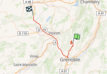

Length
72 km

Max alt
1694 m

Uphill gradient
1286 m
Km-Effort
92 km

Min alt
188 m

Downhill gradient
2148 m
Boucle
No
Creation date :
2021-01-31 09:29:36.0
Updated on :
2021-02-01 22:25:20.477
6h30
Difficulty : Unknown

FREE GPS app for hiking
 SityTrail
IGN / Geographical institutes
SityTrail Plus
The world is yours!
About
Trail Touring skiing of 72 km to be discovered at Auvergne-Rhône-Alpes, Isère, Sarcenas. This trail is proposed by GOHIER.
Positioning
Country:
France
Region :
Auvergne-Rhône-Alpes
Department/Province :
Isère
Municipality :
Sarcenas
Location:
Unknown
Start:(Dec)
Start:(UTM)
716672 ; 5019356 (31T) N.
Comments