


12,5km - Thier à Liège

gilbertus58
User
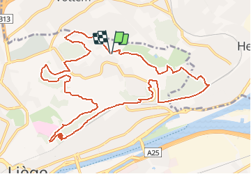

Length
12.5 km

Max alt
203 m

Uphill gradient
316 m
Km-Effort
16.7 km

Min alt
66 m

Downhill gradient
314 m
Boucle
Yes
Creation date :
2021-02-02 08:53:37.439
Updated on :
2021-02-02 08:54:51.37
3h47
Difficulty : Difficult

FREE GPS app for hiking
 SityTrail
IGN / Geographical institutes
SityTrail Plus
The world is yours!
About
Trail Walking of 12.5 km to be discovered at Wallonia, Liège, Liège. This trail is proposed by gilbertus58.
Positioning
Country:
Belgium
Region :
Wallonia
Department/Province :
Liège
Municipality :
Liège
Location:
Jupille-sur-Meuse
Start:(Dec)
Start:(UTM)
683333 ; 5615649 (31U) N.
Comments