


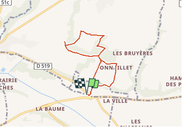
RS-Pajay-Penol-Gourras

raymondfn
User

Length
6.7 km

Max alt
365 m

Uphill gradient
111 m
Km-Effort
8.1 km

Min alt
285 m

Downhill gradient
111 m
Boucle
Yes
Creation date :
2021-02-02 10:20:57.101
Updated on :
2021-03-27 08:30:44.785
1h51
Difficulty : Medium

FREE GPS app for hiking
 SityTrail
IGN / Geographical institutes
SityTrail Plus
The world is yours!
About
Trail Walking of 6.7 km to be discovered at Auvergne-Rhône-Alpes, Isère, Penol. This trail is proposed by raymondfn.
Description
Montée courte mais un peu raide au départ : dénivelé de 30 m en 150 m de parcours
Positioning
Country:
France
Region :
Auvergne-Rhône-Alpes
Department/Province :
Isère
Municipality :
Penol
Location:
Unknown
Start:(Dec)
Start:(UTM)
666796 ; 5022655 (31T) N.
Comments