


bois de la gaillarde

vincente204
User

Length
16.9 km

Max alt
247 m

Uphill gradient
635 m
Km-Effort
25 km

Min alt
16 m

Downhill gradient
635 m
Boucle
Yes
Creation date :
2021-02-02 07:52:12.271
Updated on :
2021-02-02 14:34:30.327
6h41
Difficulty : Easy

FREE GPS app for hiking
 SityTrail
IGN / Geographical institutes
SityTrail Plus
The world is yours!
About
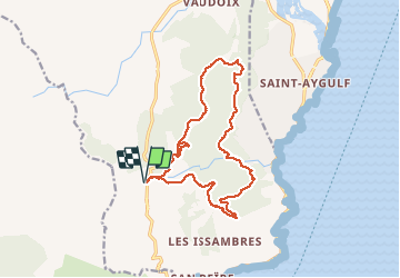
Trail Walking of 16.9 km to be discovered at Provence-Alpes-Côte d'Azur, Var, Roquebrune-sur-Argens. This trail is proposed by vincente204.
Description
difficile
Positioning
Country:
France
Region :
Provence-Alpes-Côte d'Azur
Department/Province :
Var
Municipality :
Roquebrune-sur-Argens
Location:
Unknown
Start:(Dec)
Start:(UTM)
311454 ; 4803803 (32T) N.
Comments