


robion rocher de baud et

Dan30
User
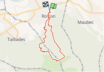

Length
8.2 km

Max alt
499 m

Uphill gradient
434 m
Km-Effort
14 km

Min alt
139 m

Downhill gradient
438 m
Boucle
Yes
Creation date :
2021-02-02 09:05:00.879
Updated on :
2021-02-02 15:01:37.564
5h23
Difficulty : Very easy

FREE GPS app for hiking
 SityTrail
IGN / Geographical institutes
SityTrail Plus
The world is yours!
About
Trail Walking of 8.2 km to be discovered at Provence-Alpes-Côte d'Azur, Vaucluse, Robion. This trail is proposed by Dan30.
Positioning
Country:
France
Region :
Provence-Alpes-Côte d'Azur
Department/Province :
Vaucluse
Municipality :
Robion
Location:
Unknown
Start:(Dec)
Start:(UTM)
669845 ; 4856903 (31T) N.
Comments