


Vrocourt Montperthuis Gerberoy

ioudina
User

Length
16.3 km

Max alt
215 m

Uphill gradient
294 m
Km-Effort
20 km

Min alt
106 m

Downhill gradient
295 m
Boucle
Yes
Creation date :
2014-12-10 00:00:00.0
Updated on :
2014-12-10 00:00:00.0
2h31
Difficulty : Easy

FREE GPS app for hiking
 SityTrail
IGN / Geographical institutes
SityTrail Plus
The world is yours!
About
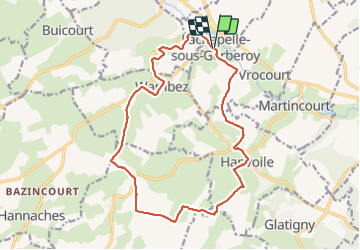
Trail Equestrian of 16.3 km to be discovered at Hauts-de-France, Oise, Lachapelle-sous-Gerberoy. This trail is proposed by ioudina.
Positioning
Country:
France
Region :
Hauts-de-France
Department/Province :
Oise
Municipality :
Lachapelle-sous-Gerberoy
Location:
Unknown
Start:(Dec)
Start:(UTM)
418196 ; 5487619 (31U) N.
Comments