


20210203 Pointe de Trevignac

Childebert
User
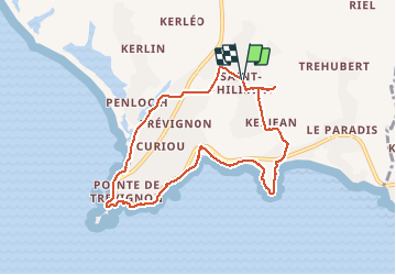

Length
8 km

Max alt
24 m

Uphill gradient
51 m
Km-Effort
8.7 km

Min alt
1 m

Downhill gradient
53 m
Boucle
Yes
Creation date :
2021-02-03 10:19:44.539
Updated on :
2021-02-03 14:51:08.289
3h02
Difficulty : Easy

FREE GPS app for hiking
 SityTrail
IGN / Geographical institutes
SityTrail Plus
The world is yours!
About
Trail Walking of 8 km to be discovered at Brittany, Finistère, Trégunc. This trail is proposed by Childebert.
Positioning
Country:
France
Region :
Brittany
Department/Province :
Finistère
Municipality :
Trégunc
Location:
Unknown
Start:(Dec)
Start:(UTM)
437673 ; 5295027 (30T) N.
Comments