


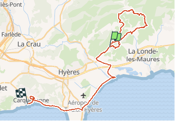
L’apié Gaoutabry les dolmens

BerFran
User

Length
40 km

Max alt
239 m

Uphill gradient
878 m
Km-Effort
52 km

Min alt
-2 m

Downhill gradient
913 m
Boucle
No
Creation date :
2021-02-03 07:51:28.0
Updated on :
2021-02-03 16:37:56.733
6h00
Difficulty : Medium

FREE GPS app for hiking
 SityTrail
IGN / Geographical institutes
SityTrail Plus
The world is yours!
About
Trail Walking of 40 km to be discovered at Provence-Alpes-Côte d'Azur, Var, Hyères. This trail is proposed by BerFran.
Positioning
Country:
France
Region :
Provence-Alpes-Côte d'Azur
Department/Province :
Var
Municipality :
Hyères
Location:
Unknown
Start:(Dec)
Start:(UTM)
271355 ; 4780860 (32T) N.
Comments