Trail Walking Bretonvillers - Bretonvillers - Saucet - Photo
 fredfred
fredfred

User

© OpenStreetMap contributors
Length
Length
9.8 km
Max alt
Max alt
822 m
Uphill gradient
Uphill gradient
441 m
Km-Effort
Km-Effort  
15.7 km
Min alt
Min alt
448 m
Downhill gradient
Downhill gradient
443 m
Boucle
Boucle
Yes
Creation date :
2014-12-10 00:00:00.0
Updated on :
2014-12-10 00:00:00.0

(2 Reviews)

Walking
Walking
3h14
Difficulty : Easy

Scan this QR Code to open this trail in the SityTrail application

FREE GPS app for hiking

Logo SityTrail SityTrail

IGN / Geographical institutes

Download SityTrail from the App Store Download SityTrail from Google Play

Logo SityTrail SityTrail World

The world is yours!

Download SityTrail from the App Store Download SityTrail from Google Play Download SityTrail on Huawei AppGallery

About

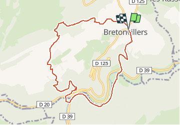
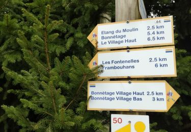
Trail Walking of 9.8 km to be discovered at Bourgogne-Franche-Comté, Doubs, Bretonvillers. This trail is proposed by fredfred.

Description

Du magazine En Vadrouille 2014

Elevation profile

Positioning

Country:
France
Region :
Bourgogne-Franche-Comté
Department/Province :
Doubs
Municipality :
Bretonvillers
Location:
Unknown
Start:(UTM)
321110 ; 5232120 (32T) N.

Comments

Please log in to post a review or rate the element


Très bonne randonnée.


bonne randonnée!


Trails nearby

Trail Walking Montbéliardot - arboretum - Photo
Walking
amnesik

Walking

Very easy
Montbéliardot, Bourgogne-Franche-Comté, Doubs, France
4 km | 5 km-effort
1h 11min
Yes
Trail Walking Plaimbois-du-Miroir - Plaimbois du Miroir  - Photo
Walking
klopbill

Walking

Difficult
Plaimbois-du-Miroir, Bourgogne-Franche-Comté, Doubs, France
14.9 km | 22 km-effort
6h 22min
No
Trail Walking Bretonvillers - rando gigot  - Photo
Walking
mig26

Walking

Medium
Bretonvillers, Bourgogne-Franche-Comté, Doubs, France
16.7 km | 25 km-effort
4h 12min
Yes
Trail Walking Bonnétage - Bon étage haut eglîse - Photo
Walking
lime

Walking

Medium
Bonnétage, Bourgogne-Franche-Comté, Doubs, France
14.3 km | 18.2 km-effort
4h 35min
No
Trail Walking Vaucluse - vaucluse - Photo
Walking
cherlieu

Walking

Very difficult
Vaucluse, Bourgogne-Franche-Comté, Doubs, France
20 km | 29 km-effort
6h 10min
Yes
Trail Walking Vaucluse - vaucluse - Photo
Walking
eltonnermou

Walking

Medium
Vaucluse, Bourgogne-Franche-Comté, Doubs, France
14.9 km | 20 km-effort
2h 25min
Yes
Trail Other activity Charmoille - charmoille - Photo
Other activity
alexbnmr

Other activity

Very easy
(1)
Charmoille, Bourgogne-Franche-Comté, Doubs, France
25 km | 31 km-effort
4h 17min
No
Trail Walking Chamesey - 123 - Photo
Walking
cherlieu

Walking

Very difficult
Chamesey, Bourgogne-Franche-Comté, Doubs, France
41 km | 58 km-effort
12h 45min
Yes
Trail Walking Belleherbe - belleherbe - Photo
Walking
cherlieu

Walking

Difficult
Belleherbe, Bourgogne-Franche-Comté, Doubs, France
22 km | 31 km-effort
8h 13min
Yes


Close
My subscriptions