


Run 04/02

GioA10
User
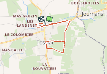

Length
3.8 km

Max alt
276 m

Uphill gradient
23 m
Km-Effort
4.1 km

Min alt
262 m

Downhill gradient
25 m
Boucle
Yes
Creation date :
2021-02-04 05:09:20.0
Updated on :
2021-02-04 05:32:05.137
21m
Difficulty : Unknown

FREE GPS app for hiking
 SityTrail
IGN / Geographical institutes
SityTrail Plus
The world is yours!
About
Trail Running of 3.8 km to be discovered at Auvergne-Rhône-Alpes, Ain, Tossiat. This trail is proposed by GioA10.
Positioning
Country:
France
Region :
Auvergne-Rhône-Alpes
Department/Province :
Ain
Municipality :
Tossiat
Location:
Unknown
Start:(Dec)
Start:(UTM)
678927 ; 5112421 (31T) N.
Comments